
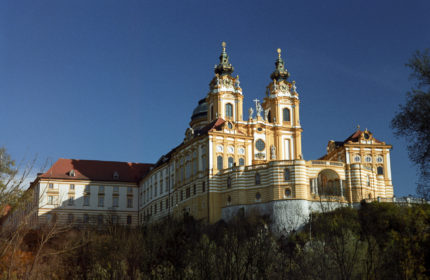
Melk monastery
After leaving Mauthausen, we followed the Danube for a couple of days, and the scenery changed drastically from one day to another. The second day was prettier. We were glad to be there during the Fall, when there were less tourists, because the rainbow of colors in the trees kept us company on what would have otherwise been a lonely route. Granted, we’re here off-season, but where are all the people? Not many in Austria. By mid-afternoon, the moon was already out, its white circular form casting its reflection over the misty river.
We were heading towards the Wachau region, a marvelous 30-km.(18-mi.)stretch along the Danube which is classified by the UNESCO. It is known for its apricot orchards and its vineyard-covered hillsides dotted with monasteries, churches, castles, and ruins. For more information on the UNESCO World Heritage site, please click here.
We were anxious to reach Melk, the first city along the Wachau route, so we awoke very early and biked the remaining 10 mi. to the town. Unfortunately, fog covered the entire river valley until almost noon. So that we missed passing by the Maria Taferl castle and other fortresses. The fog was so thick that we didn’t even see the river.
When we reached Melk, we couldn’t even see the monastery at the top of the hill, so we lunched and waited several hours for the fog to clear. After negotiating a very steep hill, we reached the top, only to find out that we could only visit the monastery with a guide, and that the tour of the day was already finished. So we toured the extensive grounds and visited the church altar, the only part that was open. From what we could see, it was very richly decorated in Baroque style – a lot of gilded ornamentation. A LOT. We were disappointed not to have visited the church or the library, but we toured the pretty Renaissance town with its fountain at the town square, the pastel-colored houses on the hill, and the wrought-iron sign posts.
We slept just outside of town that night along the river, and the next day continued on the Wachau path to Schonbuhel Castle, built along the riverbanks in the 12th century. We watched fishermen make a big catch from the banks, then release the fish back into the water.
It took the two of us pushing each bike to get up that hill!
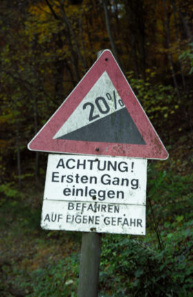
As the afternoon drew on, we reached the town of Aggsbach. Stephane had been talking for two days about wanting to sleep inside the ruins of Aggstein Castle. As I looked 1000 ft. up the steep cliff, I almost lost heart. Plus, it was less than 1/2 hour before the sun would set. It was only the hopeful look on his face and in his voice that made me swallow my protests. (Is that love or what!) Less than a minute later, a sign announced that it would be a 20% incline all the way up, and I was already off the bike. 1000 ft. in 1.5 mi. It took the two of us all of our efforts just to push one bike, so we did the mountain two times, first with Stephane’s bike, then with mine.
Just after starting up the mountainside, a darkness set in – a complete and total darkness – because the thick blanket of trees effectively blocked all moonlight. Just us and the darkness for a couple of hours. I found myself thinking about the captives of the baron nicknamed “Terror of the Woods” as they headed up this cliff to a terrifying fate, either to be starved or pushed over the cliff.
After what seemed like an eternity, we saw light breaking through the forest, meaning we were nearing the top. Then, as the moonlight broke through in full force, it illuminated the remains of Aggstein Castle in front of us. In contrast to the complete blackness we had been absorbed in, the moon seemed a powerful floodlamp. The castle was impressive, sitting as it was on the edge of the cliff. It was huge, one of the largest castle grounds in Austria. We explored the area by foot, then set up our tent just a few yards to the right side of the castle, the cilff’s edge in front of us and a large rock wall behind us. We sat on a rock and overlooked the castle and the river valley. The cars passing by down below us seemed miniature (a little like ants, I thought), signs of a far-away civilization.
We awoke before the sun the next morning and climbed the rocks to have the best view. We were above even the castle, and had the advantage of being at one of the highest spots in the region. We had a view of the entire river valley, as yet covered in morning fog. Only the castle was high eough to be free of fog. As the sun rose over the mountains and covered the trees and the castle in a red glow, I was glad that we had come to the top. Nowhere else would we have this view. And the beauty was uniquely ours that morning.
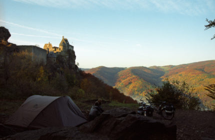
Amazing view from our camp
We waited until 9 o’clock before entering the castle, but we didn’t get much past the front door when the construction foreman came to tell us it was closed. I asked what time they opened, and he said, “April!” Surprised, we tried to explain that we had come all the way to the top with our bikes, but he just repeated grumpily, “We’re closed!”
The foreman left and Stephane insisted on taking a quick tour. After all, we had pushed the bikes for several hours up the mountainside the night before. It wasn’t to be turned away summarily the next morning. So we toured the ruins, the only ones there besides the construction workers, who watched us silently as we climbed narrow ladders and went from one room to another. We had an excellent view from the top ramparts. We saw the “rose garden,” the cliff where the prisoners were pushed to their deaths.
After the quick descent through the yellow and amber-colored forest, we continued along the south bank of the river, passing apricot groves and stopping alongside a stone beach to look across the river at the village of Willendorf, the town rendered famous after the discovery in 1908 of a limestone statuette dating back 25,000 years. Used for worshipping purposes and considered the symbol of fertility, it is nicknamed “The Venus of Willendorf” and can be seen at the Natural History Museum in Vienna.
We took a cable-powered ferry across the river to Spitz, which is at the foothill of vineyard-covered hills. It was a picturesque town, set on a 20% slope, with pastel houses and an historic town square in front of the church. We watched a group of schoolboys playing during their lunch break.
Just over 1 mi. farther along the river, we came to the town of St. Michael, a town with only a few houses, but known for its church, which is seen as the elemental church, and thus the “mother” of all the churches in the Wachau. It was built as a defense against the Turks around 1600. It is a beatifully simple church and has a lovely cemetery overlooking the river.
Durnstein wasn’t far away. It can be seen in the distance by its unique blue and white church steeple. The town is famous for having imprisoned King Richard the Lion-Hearted, who was captured in 1192 during the 3rd Crusade after trying to make his way back to England after a shipwreck. He had apparently insulted Duke Leopold V von Babenburg and was thus imprisoned at the Durnstein Castle. He was discovered by his faithful minstrel Blondel, who travelled from castle to castle singing the king’s favorite songs. King Richard was ransomed for fifteen tons of silver bars, which was used to finance the construction of other churches and palatial residences in the Wachau.
Durnstein is considered to be a “crown jewel” among the region’s vineyards and rich history. Its blue church tower is a major landmark of the entire Wachau region. The medieval city wall and dense architecture conjure up images of a bygone era. Several houses actually incorporate the ruins of this wall into their structure. Some of the houses were pink or mint green. Many houses lining the narrow streets in the city center have crests depicting various guilds. We would ave been happy to spend more time here.
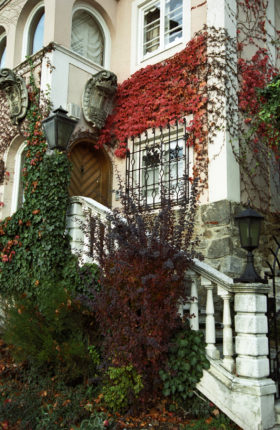
Architecture, Wachau region
After passing the night within the city limits of Stein along a river promenade, we spent the day visitng the twin cities of Krems and Stein. They were small picturesque towns full of charm. The parish church of St. Nikolaus, built in 1263, was remarkable for its brilliant altar windows, gilded paintings, and dark, exquisitely carved oak benches with plush red velvet seat cushions.
There was a plaque on the wall in memory of the town’s many soldiers which lost their lives during the Second World War. I looked at the names to see which names were popular: Josef, Johann, Franz, Leopold, and Karl.
The adjoining town, Krems, celebrated its 1000th birthday in 1995. Its buildings have facades from the medieval, Renaissance, classicist, and baroque eras, testifying to the city’s continuing development. Various monuments remind us of military battles and occupations. We wandered among the pedestrian streets and looked in at the modern shops, as well as courtyards that dated back centuries. We saw several churches, one of which was notable for the woodwork carvings on its altar which depicted not only the martyrdom of Jesus but also 12 other scenes in which men are brutally beaten and killed, all by different methods. Some are stabbed, some are flayed, quartered, and burned alive. In contrast to the pain suffered in the foreground, the backgrounds almost invariably show glorious knights and royal palaces. The carvings are quite detailled, and ironically (or maybe not) quite violent for a church.
We climbed to the city’s hilltop, where there is a panoramic view of the beginning (or end) of the Wachau Valley. We spent several days in the Wachau region, which was our favorite region thus far. We eagerly explored the monasteries, churches, and castles which greeted us at every bend in the river. It was impressive. It was beautiful. It was inspiring. An unforgettable experience.

![IMG_8196[1]](https://travleur.com/wp-content/gallery/all-countries/IMG_81961.JPG?t=1467695471 "IMG_8196[1]")
![IMG_8184[1]](https://travleur.com/wp-content/gallery/all-countries/IMG_81841.JPG?t=1467695935 "IMG_8184[1]")
![IMG_8235[1]](https://travleur.com/wp-content/gallery/all-countries/IMG_82351.JPG?t=1467698217 "IMG_8235[1]")
![IMG_8191[1]](https://travleur.com/wp-content/gallery/all-countries/IMG_81911.JPG?t=1467705538 "IMG_8191[1]")
![IMG_8226[1]](https://travleur.com/wp-content/gallery/all-countries/IMG_82261.JPG?t=1467695932 "IMG_8226[1]")
![IMG_8219[1]](https://travleur.com/wp-content/gallery/all-countries/IMG_82191.JPG?t=1467705924 "IMG_8219[1]")
![IMG_8214[1]](https://travleur.com/wp-content/gallery/all-countries/IMG_82141.JPG?t=1467696493 "IMG_8214[1]")
![IMG_8195[1]](https://travleur.com/wp-content/gallery/all-countries/IMG_81951.JPG?t=1467697626 "IMG_8195[1]")
![IMG_8200[1]](https://travleur.com/wp-content/gallery/all-countries/IMG_82001.JPG?t=1467695998 "IMG_8200[1]")
![IMG_8233[1]](https://travleur.com/wp-content/gallery/all-countries/IMG_82331.JPG?t=1467695962 "IMG_8233[1]")
![IMG_8230[1]](https://travleur.com/wp-content/gallery/all-countries/IMG_82301.JPG?t=1467709238 "IMG_8230[1]")
![IMG_8207[1]](https://travleur.com/wp-content/gallery/all-countries/IMG_82071.JPG?t=1467709042 "IMG_8207[1]")
![IMG_8212[1]](https://travleur.com/wp-content/gallery/all-countries/IMG_82121.JPG?t=1474878234 "IMG_8212[1]")
![IMG_8185[1]](https://travleur.com/wp-content/gallery/all-countries/IMG_81851.JPG?t=1467708504 "IMG_8185[1]")
![IMG_8224[1]](https://travleur.com/wp-content/gallery/all-countries/IMG_82241.JPG?t=1467697634 "IMG_8224[1]")
![IMG_8202[1]](https://travleur.com/wp-content/gallery/all-countries/IMG_82021.JPG?t=1467695483 "IMG_8202[1]")
![IMG_8217[1]](https://travleur.com/wp-content/gallery/all-countries/IMG_82171.JPG?t=1467706383 "IMG_8217[1]")
![IMG_8192[1]](https://travleur.com/wp-content/gallery/all-countries/IMG_81921.JPG?t=1467710573 "IMG_8192[1]")
![IMG_8190[1]](https://travleur.com/wp-content/gallery/all-countries/IMG_81901.JPG?t=1467696272 "IMG_8190[1]")
![IMG_8204[1]](https://travleur.com/wp-content/gallery/all-countries/IMG_82041.JPG?t=1467705451 "IMG_8204[1]")
![IMG_8225[1]](https://travleur.com/wp-content/gallery/all-countries/IMG_82251.JPG?t=1467697658 "IMG_8225[1]")
![IMG_8211[1]](https://travleur.com/wp-content/gallery/all-countries/IMG_82111.JPG?t=1467695552 "IMG_8211[1]")
![IMG_8193[1]](https://travleur.com/wp-content/gallery/all-countries/IMG_81931.JPG?t=1467695466 "IMG_8193[1]")
![IMG_8215[1]](https://travleur.com/wp-content/gallery/all-countries/IMG_82151.JPG?t=1467710529 "IMG_8215[1]")
![IMG_8176[1]](https://travleur.com/wp-content/gallery/all-countries/IMG_81761.JPG?t=1467708584 "IMG_8176[1]")
![IMG_8208[1]](https://travleur.com/wp-content/gallery/all-countries/IMG_82081.JPG?t=1467695523 "IMG_8208[1]")
![IMG_8175[1]](https://travleur.com/wp-content/gallery/all-countries/IMG_81751.JPG?t=1467711077 "IMG_8175[1]")
![IMG_8227[1]](https://travleur.com/wp-content/gallery/all-countries/IMG_82271.JPG?t=1467699395 "IMG_8227[1]")
![IMG_8216[1]](https://travleur.com/wp-content/gallery/all-countries/IMG_82161.JPG?t=1467705551 "IMG_8216[1]")
![IMG_8236[1]](https://travleur.com/wp-content/gallery/all-countries/IMG_82361.JPG?t=1467710103 "IMG_8236[1]")
![IMG_8223[1]](https://travleur.com/wp-content/gallery/all-countries/IMG_82231.JPG?t=1467697637 "IMG_8223[1]")
![IMG_8205[1]](https://travleur.com/wp-content/gallery/all-countries/IMG_82051.JPG?t=1467709010 "IMG_8205[1]")
![IMG_8177[1]](https://travleur.com/wp-content/gallery/all-countries/IMG_81771.JPG?t=1467695939 "IMG_8177[1]")
![IMG_8188[1]](https://travleur.com/wp-content/gallery/all-countries/IMG_81881.JPG?t=1467695450 "IMG_8188[1]")
![IMG_8209[1]](https://travleur.com/wp-content/gallery/all-countries/IMG_82091.JPG?t=1467708660 "IMG_8209[1]")
![IMG_8231[1]](https://travleur.com/wp-content/gallery/all-countries/IMG_82311.JPG?t=1467708263 "IMG_8231[1]")
![IMG_8186[1]](https://travleur.com/wp-content/gallery/all-countries/IMG_81861.JPG?t=1467696176 "IMG_8186[1]")
![IMG_8181[1]](https://travleur.com/wp-content/gallery/all-countries/IMG_81811.JPG?t=1467709010 "IMG_8181[1]")
![IMG_8234[1]](https://travleur.com/wp-content/gallery/all-countries/IMG_82341.JPG?t=1467708307 "IMG_8234[1]")
![IMG_8187[1]](https://travleur.com/wp-content/gallery/all-countries/IMG_81871.JPG?t=1474890799 "IMG_8187[1]")
![IMG_8213[1]](https://travleur.com/wp-content/gallery/all-countries/IMG_82131.JPG?t=1467695561 "IMG_8213[1]")
![IMG_8201[1]](https://travleur.com/wp-content/gallery/all-countries/IMG_82011.JPG?t=1467695971 "IMG_8201[1]")
![IMG_8180[1]](https://travleur.com/wp-content/gallery/all-countries/IMG_81801.JPG?t=1474890917 "IMG_8180[1]")
![IMG_8178[1]](https://travleur.com/wp-content/gallery/all-countries/IMG_81781.JPG?t=1467708261 "IMG_8178[1]")
![IMG_8206[1]](https://travleur.com/wp-content/gallery/all-countries/IMG_82061.JPG?t=1467710615 "IMG_8206[1]")
![IMG_8197[1]](https://travleur.com/wp-content/gallery/all-countries/IMG_81971.JPG?t=1467710529 "IMG_8197[1]")
![IMG_8189[1]](https://travleur.com/wp-content/gallery/all-countries/IMG_81891.JPG?t=1467695454 "IMG_8189[1]")
![IMG_8194[1]](https://travleur.com/wp-content/gallery/all-countries/IMG_81941.JPG?t=1467695468 "IMG_8194[1]")
![IMG_8210[1]](https://travleur.com/wp-content/gallery/all-countries/IMG_82101.JPG?t=1467696871 "IMG_8210[1]")
![IMG_8198[1]](https://travleur.com/wp-content/gallery/all-countries/IMG_81981.JPG?t=1467696848 "IMG_8198[1]")
![IMG_8199[1]](https://travleur.com/wp-content/gallery/all-countries/IMG_81991.JPG?t=1467710102 "IMG_8199[1]")
![IMG_8182[1]](https://travleur.com/wp-content/gallery/all-countries/IMG_81821.JPG?t=1467694560 "IMG_8182[1]")
![IMG_8218[1]](https://travleur.com/wp-content/gallery/all-countries/IMG_82181.JPG?t=1467695590 "IMG_8218[1]")
![IMG_8179[1]](https://travleur.com/wp-content/gallery/all-countries/IMG_81791.JPG?t=1467705525 "IMG_8179[1]")
![IMG_8228[1]](https://travleur.com/wp-content/gallery/all-countries/IMG_82281.JPG?t=1467699828 "IMG_8228[1]")
![IMG_8183[1]](https://travleur.com/wp-content/gallery/all-countries/IMG_81831.JPG?t=1467698693 "IMG_8183[1]")
![IMG_8203[1]](https://travleur.com/wp-content/gallery/all-countries/IMG_82031.JPG?t=1467695485 "IMG_8203[1]")